Hurricane Season Arrives in the Keys
Bascom Grooms May 30, 2024
Bascom Grooms May 30, 2024
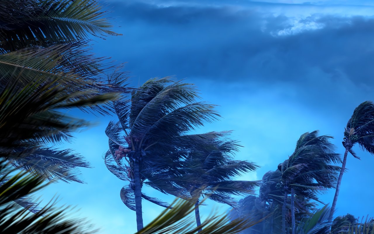
Hurricanes are a part of life along the Gulf and Southern Atlantic coastlines, and certainly in Florida and the Florida Keys. Miami and Key West are considered America’s most hurricane-prone cities, but people find that the attractions of life in tropical paradise are worth weathering a few storms.
Do you need to be afraid of hurricanes in Key West? It is true that the island gets a bit windy and wet at times, but people have been enjoying the upside of the Florida Keys in the form of pleasant weather, scenic beauty, and bountiful marine resources for at least 1200 years and probably much longer. The official Atlantic hurricane begins on June 1 and ends on November 30 every year. It’s just another note in the rhythm of island life on Key West. Sometimes the season gets exciting, but most often the hot summer months are broken up by a few tropical squalls and not much more.
NOAA Hurricane Research Division statistics based on 126 years of hurricane data indicate that Key West has a 16 percent probability of being impacted by a hurricane in any given year, an average of once every 6.04 years based on the records. However, averages can be deceiving, and since record keeping began, spans of up to 25 years have passed without any direct hurricane impacts on the Florida Keys. In any case, education, experience, and a little attention to seasonal preparedness go a long way in reducing fear and minimizing the impact of a hurricane or any stormy weather in Key West, and there are plenty of resources available for Key West property owners to take advantage of.
You might know a few of the more infamous hurricanes by their names. Which by the way come from six alphabetical lists of female and male names maintained by the World Meteorological Association. The lists are rotated through 6-year cycles. In the days before political correctness began advancing in the late 1970s, storms were given only female names because apparently hurricanes, being unpredictable, mercurial in mood, prone to wreck homes and cars, break china, and so on, were seen as having female characteristics.
Obviously, that was nothing but hidebound male chauvinism in action. Unfortunately, a Princeton University research team (Jung et al., 2014) that analyzed hurricane fatality data for the period 1950–2012 found that female-named storms caused significantly more deaths. This turned out to be because people viewed them as less violent and dangerous, so they failed to evacuate or prepare. In other words, false impressions given by the female lured people in, then...Well, you will have to come to your own conclusions regarding hurricane gender stereotypes.
Maybe you remember Irma, the Category 4 bad girl who took a swipe at Key West in 2017 with her sustained 132mph winds and 160mph gusts. A fortunate last-minute jog took the storm path 20 miles north of the city; Key West suffered damage, but with typical Conch resilience, recovered quickly. That was the last storm to severely impact the island. Or her big brother Ian on September 27, 2022: a Category 5 monster that produced gusts up to 216mph and dealt out $113 billion in damage to the Southwest Florida coast, making it the costliest storm in Florida history. Luck was once again with Key West as Ian, weakened by a pass over Cuba, tracked by 70 miles to the west over the uninhabited Dry Tortugas as a Category 3 with 125mph winds.
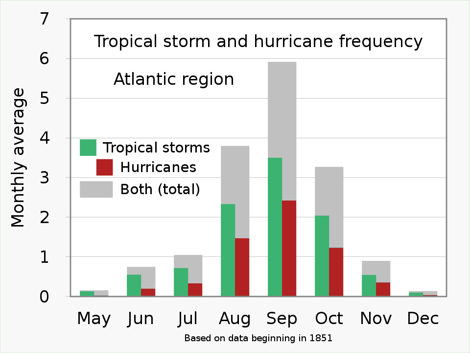
But what’s in a name anyway? Let’s take a little closer look at tropical cyclones, the storms that we call hurricanes and are known as typhoons in Asia-Pacific regions. A tropical storm (windspeed avg. 39mph+) becomes a hurricane when winds reach a sustained speed of 74mph or more. Hurricanes form over tropical oceans approximately between latitudes 5 and 20, north or south.
Hurricanes are rare below 5 degrees latitude because the weak Coriolis force near the Equator cannot cause air to spin around a region of low-pressure (tropical depression). This same force, caused by the spin of the Earth, also causes hurricanes to rotate counterclockwise in the Northern Hemisphere versus clockwise in the Southern Hemisphere. Once formed, a hurricane can vary considerably in size, but is typically about 300 miles wide, with an eye that is usually 20–30 miles wide and can extend for more than 400 miles. Over open ocean, a hurricane can move around for 2 weeks or more.
By using sediment core data from the Puerto Rican island of Vieques, researchers have tracked historical hurricane activity levels going back 5,000 years. The earliest written hurricane record dates to 1523, and from that time into the 19th century, ship’s logs, the recounted experiences of ocean-going men, and information and stories from people who lived along coastlines and on islands made up the body of knowledge about hurricane activity. The United States Weather Bureau began collecting official data on tropical cyclones in 1851, but observations were limited to storms that impacted populated areas. Ships, coastal observers, and land-based weather stations were the primary sources of information.
The launch of the first weather satellite in 1961 marked the beginning of modern hurricane tracking and data collection. Satellites can detect and monitor hurricanes over the open ocean, allowing far more comprehensive and accurate storm counts and tracking information. Storm tracking has continued to improve along with technology, and now advanced satellite thermal imaging and the power of supercomputers like the system at the European Center for Medium-Range Weather Forecasting, considered the world’s most accurate and reliable, allow highly accurate predictions of storm track and intensity.
Tropical Cyclone Centers located around the world are dedicated to the purposes of hurricane research, forecasting, and monitoring. They include the U.S. National Hurricane Center, the U.S. Central Pacific Hurricane Center, and a number of others. Other agencies, for example the National Weather Service and the National Oceanographic and Atmospheric Administration, also have divisions dedicated to hurricane-related work.
Fortunately, most hurricanes that affect Florida and the Eastern Seaboard begin far out at sea off west Africa in the Atlantic. Some form in the Gulf of Mexico and the Caribbean Sea to the east of Mexico and South America. Modern technology allows detection and tracking to begin even before storm formation. There is always adequate warning; although last-minute changes of strength and course are a constant risk. Many problems stem from people failing to take warnings seriously or ignoring them completely. In Key West, at the end of the single road that serves the Florida Keys, evacuation planning has always been a primary concern.
Nowadays, smart phone apps, instant access to weather information, and emergency alert broadcasts make it easy to maintain a heightened state of awareness during hurricane season. The Watch and Warning system is as follows:
Realistically, hurricanes are far less dangerous than the fires, tornadoes, river flooding, or earthquakes that are commonly encountered in other parts of the country. Educating yourself and your loved ones, maintaining a basic level of preparedness, and keeping an eye on the weather can greatly increase your margin of safety, reduce the chances of severe property damage, and let you handle hurricane season with the equanimity of a seasoned Conch.
Many destructive storms that affected the Caribbean islands and Florida centuries before the advent of organized data collection are known from early written records of various types. Perhaps among the most legendary are two storms that struck a Spanish treasure fleet sailing from Havana in the autumn of 1622.
The first hurricane caught 28 ships of the Terre Firme fleet off the Keys on September 5, 1622. Eight ships were sunk or grounded between the Dry Tortugas and Key West, including the galleon Nuestra Señora de Atocha, one of the largest and most heavily armed ships in the Spanish fleet. A second hurricane struck a month later on October 5, breaking the wreck of the Atocha at the gun ports and washing the gun deck away from the lower hull. Driven by the storm, the deck floated several miles away, spilling cannon as it went.
The second hurricane, along with water depths of around 60 feet where the hull laid, ended Spanish hopes of salvaging the ship’s cargo of treasure that included 24 tons of silver bullion, 180,000 silver coins, and 125 gold bars and discs. Almost 350 years later, in 1969, legendary treasure hunter Mel Fisher began a search for the Atocha. In 1971, Fisher and his crew began to recover pieces of the scattered treasure. Thrown off the trail by the randomly-dropped cannon, it took 16 years of searching before Fisher and his team found the main body of the $400 million dollar treasure in 1985.
At Bascom Grooms Real Estate, we can guarantee almost 100% that it will not take you 16 years to uncover the Key West or Lower Keys home of your dreams, and you won’t necessarily need a boat either. Unless you are looking for the ultimate private island hideaway. Take a few minutes to browse through the beautiful Key West properties on our website, then get in touch and let us know how we can help.
Bascom Grooms Real Estate — 1110 Truman Avenue, Key West Florida — (305) 748-2057 — [email protected]


Overall inventory is up, with 332 more homes listed than at this time last year.

The 2024 edition was a standout, even for an event that is legendary.
The amazing Labor Day weekend that kicked off with the official Jimmy Buffett Day.

Jimmy Buffett honed his art as a singer-songwriter in the bars of Key West.

On Saturday evening July 20, the Key West Theater once again played host to hijinks.

Lower Keys real estate market is remaining strong despite the challenges.
Whether you are thinking of buying, selling, or investing in Florida Keys real estate, you can count on the experts at Bascom Grooms Real Estate. Contact us today to discuss all your real estate needs!